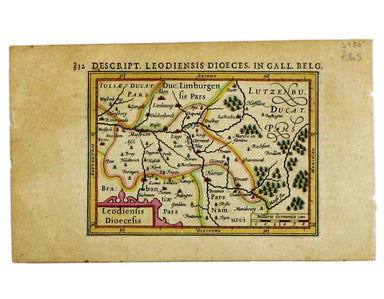
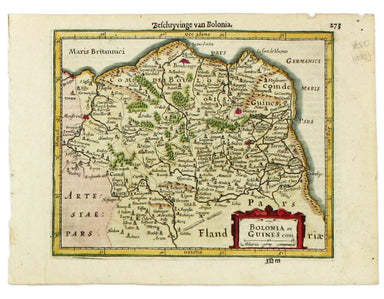
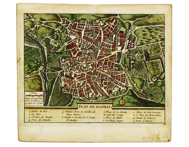
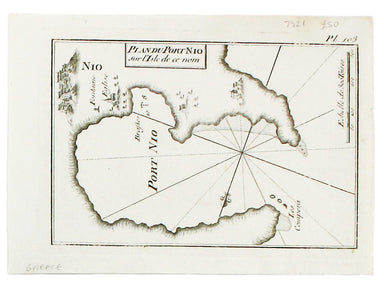
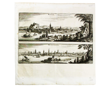
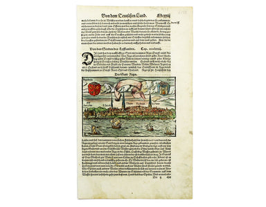
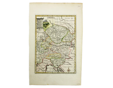
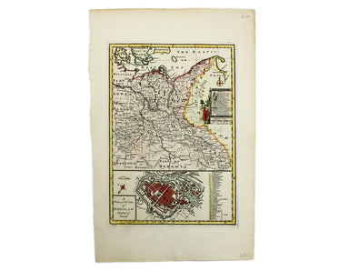
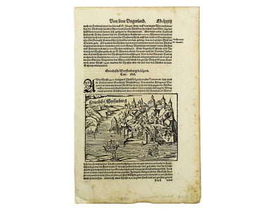
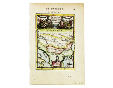
Münster’s Map of Riga
This view of the Latvian capital Riga is fromfrom Sebastian Münster's Cosmographia. A compendium of topographical information, folklore and travels...
View full detailsThis view of the Latvian capital Riga is fromfrom Sebastian Münster's Cosmographia. A compendium of topographical information, folklore and travels...
View full detailsNova Totius Germania Descriptio. Deutschland This map of Germany was published by Merian and his heirs in various works, including editions of the ...
View full detailsCondition & Materials A chart of Sète in southern France, copper engraving, 14 x 20 cm, black and white as issued, blank verso.
This map of Lyons was published by Merian and his heirs in various works, including the Archontologia Cosmica and Theatrum Europaeum. Condition &am...
View full detailsThis regional map of France is from Mallet’s Description de l’Univers. Condition & Materials Copper engraving, 15 x 10.5 cm, recent hand-colo...
View full detailsThis map of France is from Mallet’s Description de l’Univers. Condition & Materials Copper engraving, 15 x 10.5 cm, recent hand-colour, French...
View full detailsThis map of Moldavia and Transylvania is from Mallet’s Description de l’Univers. Condition & Materials Copper engraving, 15 x 11.5 cm, recent ...
View full detailsAllemagne en General This map of Northern Germany is from Mallet’s Description de l’Univers. Condition & Materials Copper engraving, 15.5 x 11....
View full detailsThis map of Hungary is from Mallet’s Description de l’Univers. Condition & Materials Copper engraving, 15 x 11.5 cm, recent hand-colour, Frenc...
View full detailsCercle de Baverie This map of Bavaria is from Mallet’s Description de l’Univers. Condition & Materials Copper engraving, 15 x 11.5 cm, recent h...
View full detailsThis map of the Netherlands is from Mallet’s Description de l’Univers. Condition & Materials Copper engraving, 15 x 10 cm, recent hand-colour, ...
View full detailsLes 13 Cantons Suisses et leurs Alliez This map of 13 Swiss Canton is from Mallet’s Description de l’Univers. Condition & Materials Copper engr...
View full detailsThis map of the Baltic Sea was engraved by John Rapkin for the Illustrated Atlas. Vignettes including Kronstadt and St Petersburg were engraved by ...
View full detailsHere's King Christian V, as he appears in Mallet’s ‘Description de l’Univers. Condition & Materials Copper engraving, 15 x 10.5 cm, recent han...
View full detailsHere are some lovely Swedes, from from Mallet’s ‘Description de l’Univers. Condition & Materials Copper engraving, 15 x 10.5 cm, recent hand-co...
View full detailsFrance/Paîs Bas This map of France and the Low Countries is from Mallet’s ‘Description de l’Univers. Condition & Materials Copper engraving, 15...
View full detailsThis map of France is from Mallet’s Description de l’Univers. Condition & Materials Copper engraving, 15 x 10.5 cm, recent hand-colour, light ...
View full detailsCondition & Materials Copper engraving, 23 x 32.5 cm, recent hand-colour, blank verso.
Condition & Materials Copper engraving, 23 x 32.5 cm, recent hand-colour, blank verso.
Condition & Materials Copper engraving, 9.5 x 13.4 cm, recent hand-colour, Latin text on verso; miniature map of Artois.
Condition & Materials Copper engraving, 9.5 x 13.4 cm, recent hand-colour, Latin text on verso; map of the Zijpe polder.
Veromandui This map of the modern Aisne is named here for the Viromandui, a Belgic tribal name. Condition & Materials Copper engraving, 9.5 x 1...
View full detailsCondition & Materials Copper engraving, 9.5 x 13.4 cm, recent hand-colour, Latin text on verso; map of Hainault.
Condition & Materials Copper engraving, 9.5 x 13.4 cm, recent hand-colour, Latin text on verso; map of Liège.
A miniature map of Salzburg and Carinthia. Condition & Materials Copper engraving, 10 x 13.5 cm, recent hand-colour, Latin text on verso;
This is Mercator's map of Pays Boulonnais and Guînes from the Atlas Minor. The original plates were engraved by Jodocus Hondius, but after these we...
View full detailsThis map of Southern Lorraine is from the Atlas Minor. The original plates were engraved by Jodocus Hondius, but after these were sold to the Londo...
View full detailsThis map of Northern Lorraine is from the Atlas Minor. The original plates were engraved by Jodocus Hondius, but after these were sold to the Londo...
View full detailsThis map of Anjou is from the Atlas Minor. The original plates were engraved by Jodocus Hondius, but after these were sold to the London trade in t...
View full detailsThis map of the province of Berry in central France is from the Atlas Minor. The original plates were engraved by Jodocus Hondius, but after these ...
View full detailsCondition & Materials Copper engraving, 39.5 x 49.5 cm, engraved by J. Basire, black and white as issued, blank verso; map of Mons.
The Babenburg Family Tree The March or Margraviate of Austria had been governed by the Babenburg family since the late tenth century. In 1156 Austr...
View full detailsKriechich Wyssenburg This map of Belgrade showing the confluence of the rivers Danube and Sava at Belgrade, Serbia, is from Sebastian Münster's Cos...
View full detailsZara et Sebenic This map of Zara and Sebinico on the Croatian coast is from the second series of maps engraved for the Epitome by Philip Galle. Con...
View full detailsRome Ancienne This plan of ancient Rome is from Mallet’s Description de l’Univers, first published in Paris in 1683 and reprinted with German text ...
View full detailsLigures, Taurini etc, item Rhaetiae pars Clüver is regarded as one of the founders of historical geography; his Introductionis in universam geograp...
View full detailsThis map includes a panoramic view of Parma at its foot, blank. The Society for the Diffusion of Useful Knowledge was founded in 1826 with the high...
View full detailsA Map of Great Greece and of the Islands of Sardinia and Corsica This map of the Greek colonies in southern Italy was published in An Universal His...
View full detailsThis plan of Madrid appeared in various works including Les Delices of I'Espagne et du Portugal and La galerie agrèable du monde. Condition & M...
View full detailsThis chart of Astypalaia in the Dodecanese is from the practical pocket sea atlas by Marseilles hydrographer Joseph Roux, charting the ports and ha...
View full detailsThis significant and original regional map of Padua is from Magini's great work, the first detailed national atlas of Italy, published posthumously...
View full detailsThis significant and original regional map of Sardinia is from Magini's great work, the first detailed national atlas of Italy, published posthumou...
View full detailsThis chart of Ios in the Cyclades is from the practical pocket sea atlas by Marseilles hydrographer Joseph Roux, charting the ports and harbours of...
View full detailsThis map of Dubrovnik and Chalcis waspublished by Merian and his heirs in various works, including the Archontologia Cosmica and Theatrum Europaeum...
View full detailsCondition & Materials Copper engraving, 23 x 24.5 cm, black and white as issued, blank verso. Stadtplan of Napoleonic Venice.
Condition & Materials Copper engraving, 27.5 x 37 cm, black and white, blank verso. Map showing the Duchy of Mantua.
Turquie Septentrionale en Europe This map of the Northern Ottoman Territories is from Mallet’s Description de l’Univers. Condition & Materials ...
View full detailsCondition & Materials Copper engraving, 24.5 x 38 cm, recent hand-colour, blank verso; this map of Bologna is from Lalande’s Voyage en Italie, ...
View full details