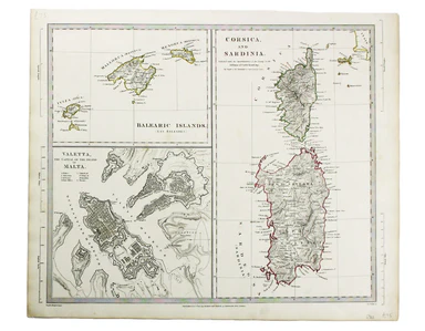
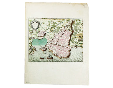
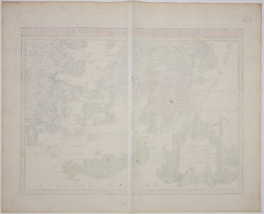
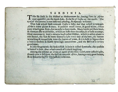
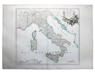
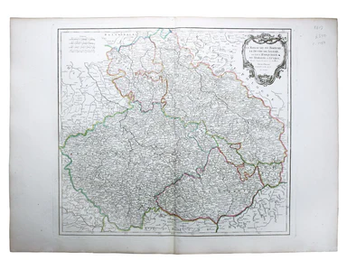
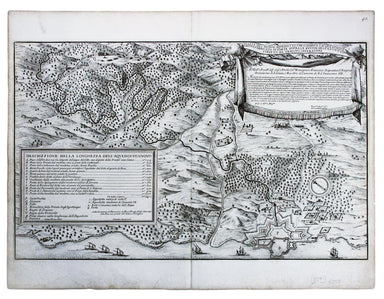
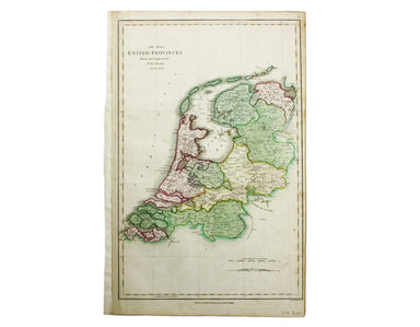
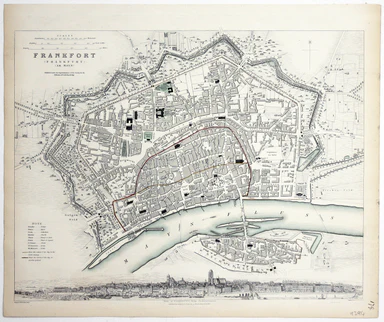
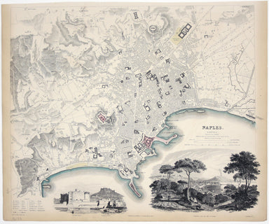
SDUK Map of the Balearics, Corsica, Sardinia & Valetta
This map of the Balearics, Corsica, Sardinia and Valetta was published by the SDUK The Society for the Diffusion of Useful Knowledge was founded in...
View full detailsThis map of the Balearics, Corsica, Sardinia and Valetta was published by the SDUK The Society for the Diffusion of Useful Knowledge was founded in...
View full detailsThis map of Turin was published by the SDUK. The Society for the Diffusion of Useful Knowledge was founded in 1826 with the high-minded aim of maki...
View full detailsScarpanto (Karpathos) This map of Karpathos was engraved by Girolamo Porro and is set in descriptive Italian text with a woodcut headpiece and hist...
View full detailsMilo (Milos) This map of Milos was engraved by Girolamo Porro and is set in descriptive Italian text with a woodcut headpiece and historiated initi...
View full detailsNegroponte (Euboea) This map of Negropoonte was engraved by Girolamo Porro and is set in descriptive Italian text with a woodcut headpiece and hist...
View full detailsIl Sito de Curzolari (and Gulf of Lepanto) This map of the gulf of Lepanto was engraved by Girolamo Porro and is set in descriptive Italian text wi...
View full detailsCerigo (Kythera) This map of Kythera was engraved by Girolamo Porro and is set in descriptive Italian text with a woodcut headpiece and historiated...
View full detailsNicsia (Naxos) This map of Naxos was engraved by Girolamo Porro and is set in descriptive Italian text with a woodcut headpiece and historiated ini...
View full detailsMetellino (Mytilene, Lesbos) This map of Mitilini was engraved by Girolamo Porro and is set in descriptive Italian text with a woodcut headpiece an...
View full detailsCondition & Materials Copper engraving, 21 x 25.5 cm, original hand-colour, on a folio leaf 37 x 29 cm, blank verso.
Scandinavia complectens Sveciae, Daniae et Norvegiae Regna ex novissimis subsidiis delineata et ad Leges Projectionis Stereographicae legitimae red...
View full detailsGraeciae Pars Meridionalis / Graciae Antiquae Tabula Nova in qua locorum situs tum ad distantias itinerarias tum ad Observationes Astronomicas exac...
View full detailsAt the foot of this map are architectural elevations of some of Rome’s most famous post-classical buildings, dominated by St Peter’s. Rome was then...
View full detailsVorstellung des Alten und Neven Athens, von dem Venetiani – schen Geographo Herrn Pat. Coronelli verzeichnet Coronelli’s plan retains features of t...
View full detailsLord Nelson explaining to the Officers the Plan of Attack previous to the Battle of Trafalgar… Position of the Combined Forces of France & Spai...
View full detailsTwo English printers dipped a toe in the vernacular atlas market at approximately the same time with pocket editions of the Ortelius atlas: ‘These ...
View full detailsCarte de l’Italie, dans laquelle sont tracées les Routes des Postes This is a later state of Robert de Vaugondy’s road map of Italy, showing the Ve...
View full detailsLe Royaume de Boheme, le Duche de Silesie, et les Marquisats de Moravie et Lusace, dressés d’apres les cartes de Muller The second state of Robert ...
View full detailsLe Royaume de Hongrie, Principaute de Transilvanie, Sclavonie, Croatie, et partie de la Principaute de Valaquie, de la Bosnie, de la Servie et de l...
View full detailsLa Bataille de Lens en Flandre gaignee par l’Armee du tres Chres[tien] Louys XIIII Roy de France ed de Navarre, Comandee par Monseigneur le Prince ...
View full detailsGerman Dominions of the King of Great Britain; Comprized under the name of Electorate of Brunswick-Luneburg and including the Dutchies of Bremen, V...
View full detailsNachtverkehr der BVG… Winter 1934/35 Published by the Berlin Transport Corporation, the BVG, this unusual passenger map and timetable details the n...
View full detailsDe Maginot – En Siegfried Line. Met alle steden, germeenten, spoorwegen, verstingen en versterkingen, bosschen, heuvels, enz. This map was publishe...
View full detailsThis map shows the ‘Germanic’ regions of Europe, including the Low Countries, Poland and Austria, engraved by Pieter van den Keere. The 'Atlas Mino...
View full detailsThis map of Hungary was engraved by John Rapkin for the ‘Illustrated Atlas’. It features vignettes, including Budapest, engraved by John Rogers. Co...
View full detailsThis map of Poland was engraved by Samuel John Neele for the atlas volume to ‘Cruttwell’s Gazeteer’, published by G & JJ Robinson. Condition &a...
View full detailsPianta del Nuovo Aquedotto che conduce l’acqua a Civita Vechia fabricato in parte sopra le ruuine dell’ antico construtto da Traiano Imperatore Thi...
View full detailsLa Castille Vieille et Nouvelle This map shows Old and New Castile in central Spain. Condition & Materials Copper engraving, 44.5 x 55.5 cm, or...
View full detailsTavola Esatta dell’antico Latio e Nova Campagna di Roma, situata sotto il quinto Clima […] Prepared by papal cartographer Innocenzo Mattaei circa 1...
View full detailsCarte Routière de la France dressée par ordre de Monsieur le Directeur Général des Ponts et Chaussées Though described in the title as a road map o...
View full detailsKreigs Expeditions Karte in Bohmen I Blat, in welchern die Haubstadt Prag mit der Franzofsischen und Saechsischen Belegerug und Eroberung, so den 2...
View full detailsDaciarum, Moesiarumque, vetus descriptio This map of Ancient Dacia and Moesia, modern Romania and Bulgaria on the Black Sea was published by Baltha...
View full detailsThis intricate anthropomorphic map (the artist also produced a zoomorphic companion piece) was issued soon after the outbreak of the First World Wa...
View full detailsThe Bay of Gibraltar. With a plan of the Town, Rocks and Fortifications of Gibraltar as they now are. Also a plan of Algezira… Copied from the Drau...
View full detailsTrans-Isula D. Condition & Materials Copper engraving, 9.5 x 13.4 cm, recent hand-colour, Latin text on verso; map of Overjissel.
The Seven United Provinces This map of the Netherlands was prepared for Playfair’s New General Atlas. Condition & Materials Copper engraving, ...
View full detailsThis map of Poland is from Mallet’s Description de l’Univers. Condition & Materials Copper engraving, 14.5 x 10.5 cm, recent hand-colour, Fren...
View full detailsThis plan of Tienen in Flanders is from the Civitates Orbis Terrarum, one of the most significant cartographic works of the late sixteenth-century,...
View full details“Hell on Wheels” War Against the Axis 1942 – 1943 – 1944 The lower panel of this map deals with operations in North Africa and Sicily, with the uni...
View full detailsThis map of Frankfurt, view of the city at the foot of the map, was published by the SDUK. The Society for the Diffusion of Useful Knowledge was fo...
View full detailsBusca, near Cuneo in Piedmont. Blaeu’s townbook of Savoy and Piedmont was first published by the Blaeu heirs in 1682, but the plates were purchased...
View full detailsThis map of Naples was published by the SDUK. The Society for the Diffusion of Useful Knowledge was founded in 1826 with the high-minded aim of mak...
View full details