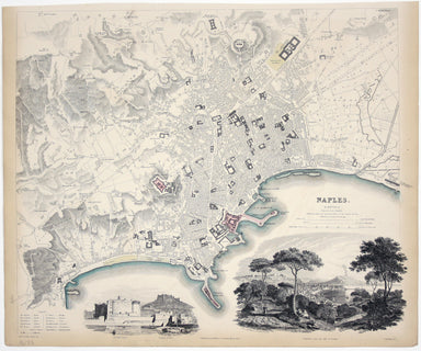
Dutch Fool’s Map
Afbeeldinge van’t zeer vermaarde Eiland Geks-Kop This Dutch ‘fool’s cap’ map satirises the bursting of the financial bubbles of 1720. Cartographic ...
View full detailsAfbeeldinge van’t zeer vermaarde Eiland Geks-Kop This Dutch ‘fool’s cap’ map satirises the bursting of the financial bubbles of 1720. Cartographic ...
View full detailsTopographia Repraesentio Barbarici Portus et Urbis Munitae Oran … Oran, an important trading port and now Algeria’s second city, was governed by th...
View full details“Hell on Wheels” War Against the Axis 1942 – 1943 – 1944 The lower panel of this map deals with operations in North Africa and Sicily, with the uni...
View full detailsFirst published in 1914, this revised edition highlights administrative boundaries. Though technically administered jointly by Egypt and Britain be...
View full detailsThis map of Frankfurt, view of the city at the foot of the map, was published by the SDUK. The Society for the Diffusion of Useful Knowledge was fo...
View full detailsCeretica sive Cardiganensis Comitatus; Anglis Cardigan Shire Blaeu and the rival Golden Age Dutch cartographic publishing house of Janssonius raced...
View full detailsBusca, near Cuneo in Piedmont. Blaeu’s townbook of Savoy and Piedmont was first published by the Blaeu heirs in 1682, but the plates were purchased...
View full detailsThis map of Naples was published by the SDUK. The Society for the Diffusion of Useful Knowledge was founded in 1826 with the high-minded aim of mak...
View full details