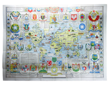
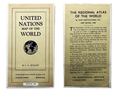
Bullock’s United Nations Map of the World
The United Nations was established in October 1945, and Bullock’s map is a joyful celebration of what promised to be a more effective successor to ...
View full detailsThe United Nations was established in October 1945, and Bullock’s map is a joyful celebration of what promised to be a more effective successor to ...
View full detailsLord Nelson explaining to the Officers the Plan of Attack previous to the Battle of Trafalgar… Position of the Combined Forces of France & Spai...
View full detailsPartie Méridionale de la Russie Européenne This is a late state of Robert de Vaugondy’s map of southern Russia, Ukraine and parts of Poland. The or...
View full detailsThis is a map of the Maluku Islands, part of the mountainous, volcanic archipelago known to Europeans as the spice islands. The islands were the fo...
View full detailsTwo English printers dipped a toe in the vernacular atlas market at approximately the same time with pocket editions of the Ortelius atlas: ‘These ...
View full detailsDistrict within ¼ mile radius [of] Uxbridge Stanford’s was a firm of map publishers as well as map retailers until after the Second World War, with...
View full detailsLower Egypt and the Adjacent Deserts with a part of Palestine; to which has been added the Nomenclature of the Roman Age… This map of of Egypt and ...
View full detailsThe guide seems to have been aimed at an American audience, with several pages devoted to converting prices in pounds, shillings and pence into dol...
View full detailsThis Central London Railway map is similar in style to the UERL common design which had been in circulation since 1908, although with a chocolate r...
View full detailsBenjamin Getzel Lewis' map of the London underground shows the Victoria Line under construction in the originally proposed colour Lewis (1900-1966)...
View full detailsThe Evening News was responsible for coining the name ‘Bakerloo Line’ for the Baker Street and Waterloo Railway, and here the newspaper makes a rel...
View full detailsTower Street Ward with their [sic] divisions into Parishes according to a new survey This plan of Tower Street was published in the greatly expande...
View full detailsCheap Ward with its divisions into Parishes according to a new survey This ward plan of Cheap was published in the greatly expanded second edition ...
View full detailsBaynard’s Castle Ward [and] Faringdon Ward with their divisions into Parishes according to a new survey This was plan of Baynard’s Castle and Farin...
View full detailsCarte de l’Italie, dans laquelle sont tracées les Routes des Postes This is a later state of Robert de Vaugondy’s road map of Italy, showing the Ve...
View full detailsLe Royaume de Boheme, le Duche de Silesie, et les Marquisats de Moravie et Lusace, dressés d’apres les cartes de Muller The second state of Robert ...
View full detailsLe Royaume de Hongrie, Principaute de Transilvanie, Sclavonie, Croatie, et partie de la Principaute de Valaquie, de la Bosnie, de la Servie et de l...
View full detailsArchipel des Indes Orientales, qui comprend les Isles de la Sonde, Moluques et Philippines, tirées des Cartes du Neptune Oriental This map of Indon...
View full detailsL’Empire de la Chine dressé d’apres les Cartes de l’Atlas Chinois This detailed and relatively accurate map of China, Korea and Taiwan was derived ...
View full detailsLa Bataille de Lens en Flandre gaignee par l’Armee du tres Chres[tien] Louys XIIII Roy de France ed de Navarre, Comandee par Monseigneur le Prince ...
View full detailsPlan of Lambeth Palace 1750… from the original in the possession of Mr Singleton of Lambeth This plan of Lambeth Palace published in Ducarels’s ‘Th...
View full detailsSheet C4 from Horwood’s ‘Plan of the Cities of London and Westminster…’ Horwood’s plan is a landmark in London mapping on a number of counts. It wa...
View full detailsSheet C1 from Horwood’s ‘Plan of the Cities of London and Westminster…’ Horwood’s plan is a landmark in London mapping on a number of counts. It wa...
View full detailsEnvirons of Wembley from Rocque’s ‘An Exact Survey of the City’s of London, Westminster, ye Borough of Southwark and the Country Near Ten Miles Rou...
View full detailsThis is a view showing London before the Great Fire, from the South Bank of the Thames, including London Bridge and old St Paul’s. Principal buildi...
View full detailsThis map of South Africa, including an inset of Cape Town, was engraved by John & Charles Walker. It was published by the SDUK. The Society for...
View full detailsThese maps of Staffordshire and Shropshire are presented on one sheet. Unlike Kip and Hole, Speed and Blaeu – who all devoted an entire map-sheet t...
View full detailsGerman Dominions of the King of Great Britain; Comprized under the name of Electorate of Brunswick-Luneburg and including the Dutchies of Bremen, V...
View full detailsNachtverkehr der BVG… Winter 1934/35 Published by the Berlin Transport Corporation, the BVG, this unusual passenger map and timetable details the n...
View full detailsBlatt 29. Warmbad This map covers the Karas region in modern Namibia (then German South West Africa), which was the scene of one of the earliest at...
View full detailsSheet III – West Coast of India – from Arnol I. to Kundari I This chart shows the approaches to Bombay harbour, modern Mumbai, with significant det...
View full detailsSouth America – Magellan Strait – Western part from Punta Arenas to Cape Pillar This US naval chart of the Magellan Strait shows soundings, anchora...
View full detailsThis map (two sheets from Horwood's magnificent 32 sheet survey) includes St James’s Square, the western part of Piccadilly, Green Park, Buckingham...
View full detailsWest Indien – Haïti bis Martinique This Imperial German Naval Office chart shows sands, soundings and interior detail of relief. Condition & Ma...
View full detailsIndischer Ocea – Afrika, Ost Küst – Lindi-Bucht This Imperial German Naval Office chart shows sands, soundings etc, with interior detail of relief,...
View full detailsA chart of part of the coast of Cochin-China including Turon Harbour and the island Callao from an actual survey in June 1793. By HW Parish of the ...
View full detailsPublished in March 1935, this is a commercially available map showing the operating area of the recently formed London Passenger Transport Board, a...
View full detailsThis map of Sri Lanka was published in the first trade edition of Stanford’s ‘London Atlas’. Edward Stanford (senior) acquired Arrowmsith's stock i...
View full detailsThis map of Asia is from ‘A Modern and Ancient General Atlas, comprehending all the Empires, Kingdoms, States in the World’. William Home Lizars tr...
View full detailsThis map of Denbighshire was published in the second edition of Philemon Holland’s translation of Camden’s Britannia into English, the third printi...
View full detailsThis map of Cardiganshire was published in the second edition of Philemon Holland’s translation of Camden’s Britannia into English, the third print...
View full detailsBeck’s diagram is possibly one of the most innovative and influential designs of the twentieth century. First published in 1933, Beck remained dire...
View full detailsDistrict within ¼ mile radius [of] Paddington Praed Street Stanford’s was a firm of map publishers as well as map retailers until after the Second ...
View full detailsGarbutt believed he had ‘rescued’ the London Underground map from the clutches of Harold Hutchison and his ‘ham-fisted parody’ of Beck’s designs. H...
View full detailsThe introduction of Beck's diagram did not obviate the need for geographically accurate maps, which pinpointed the location of Underground stations...
View full detailsDe Maginot – En Siegfried Line. Met alle steden, germeenten, spoorwegen, verstingen en versterkingen, bosschen, heuvels, enz. This map was publishe...
View full detailsPort Louis is the capital and principal port of Mauritius, which remained a British colony until 1968. Condition & Materials Engraved British c...
View full detailsJapan – Honshu – South Coast – Kii Suido – Yurano Uchi and Hii Wan This sea chart covers a stretch of coastline to the south of Osaka and Wakayama ...
View full details