£250.00
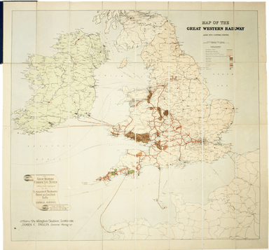
Edwardian Map of the Great Western Railway
Map of the Great Western Railway and Connections This map illustrates how the Great Western Railway connected resources such as coal fields, china ...
View full detailsMap of the Great Western Railway and Connections This map illustrates how the Great Western Railway connected resources such as coal fields, china ...
View full detailsThe earliest versions of this map advertised the Franco-British Exhibition which closed at the end of October 1908, marked here as ‘Exhibition’. In...
View full details