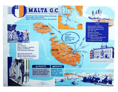
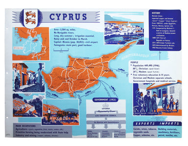
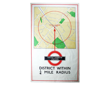
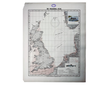
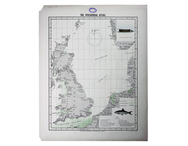
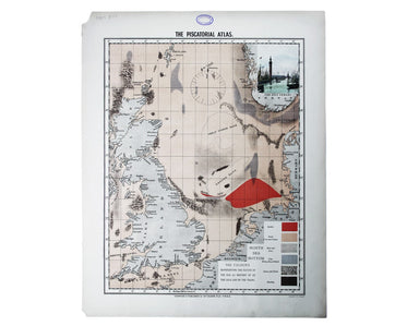
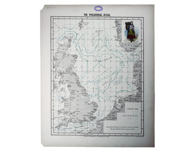
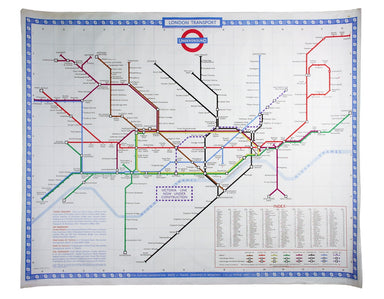
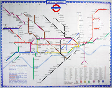
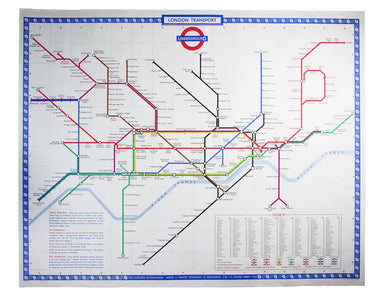
The Empire Information Project Map of Malta
Come for the Stone Age remains, stay for the rawhide... This simplified map of Malta and Gozo is surrounded by views, statistics and historical inf...
View full detailsCome for the Stone Age remains, stay for the rawhide... This simplified map of Malta and Gozo is surrounded by views, statistics and historical inf...
View full detailsThis simplified map of Cyprus was a visual aid published as sheet 4 in a portfolio titled ‘Empire Information Project. The island is surrounded by ...
View full detailsTerra Firma et Novum Regnum Granatense et Popayan This regional map covers Colombia and neighbouring parts of present day Panama, Ecuador, Costa Ri...
View full detailsPresqu’Isle des Indes Orientales, comprenant l’Indostan ou Empire du Mogol, differens Royaumes ou Etats, les vastes possessions des Anglais, et les...
View full detailsSarmatia utraque Europaea et Asiatica This map shows parts of European Russia and Ukraine in antiquity. For Greco-Roman geographers and ethnographe...
View full detailsDistrict within ¼ mile radius [of] South Harrow Stanford’s was a firm of map publishers as well as map retailers until after the Second World War, ...
View full detailsMap of the Netherlands including the Grand Duchy of Luxembourg. With the post roads and stations and the limites of Holland and Belgium This map of...
View full detailsUltimately derived from the SDUK but reflecting Haussman’s redevelopment of the city centre under Napoleon III, our example is from one of the last...
View full detailsThis map of Denmark is from Wyld's New General Atlas. James Wyld senior established a highly successful firm of map publishers, which passed to his...
View full detailsBy Green Line from Hyde Park Corner This pair poster was issued in April 1947 for the start of the first summer of the fully re-instated coach netw...
View full detailsDistrict within ¼ mile radius [of] Turnpike Lane Stanford’s was a firm of map publishers as well as map retailers until after the Second World War,...
View full detailsThis double hemisphere world map was published in the second trade edition of Stanford’s London Atlas. Edward Stanford (senior) acquired Arrowmsith...
View full detailsThe District Railway Guide to the Greater Britain Exhibition, the Gigantic Wheel, &c, at Earls Court The Greater Britain Exhibition was one of ...
View full detailsPlan of St Marylebone 1900 Detailed map of the Metropolitan Borough of St Marylebone as created by the London Government Act 1899, coloured to show...
View full detailsCarta de’ Contorni di Napoli, costrutta ed eseguita, sui piu recenti ed esatti materiali da Benedetto Marzolla, con tutte le strade postali, rotabi...
View full detailsA July 1910 map of the Uptown and Downtown Hudson Tubes, pairs of tunnels connecting Jersey City with Greenwich Village in New York and with the Hu...
View full detailsMap with lines showing the boundary for free collection and delivery of parcels and passengers’ luggage The main map shows central London, includin...
View full detailsDo you prefer your flatfish with eyes to the right, or to the left? This map was published in the ‘Piscatorial Atlas of the North Sea, English and ...
View full detailsThe fish with a face only a mother could love This map was published in the ‘Piscatorial Atlas of the North Sea, English and George’s Channels’, a ...
View full detailsMeunière your skate wings, or get someone else to do it for you This map was published in the ‘Piscatorial Atlas of the North Sea, English and Geor...
View full detailsWhy is it proverbially assumed to be very easy to run a whelk stall? They look like hard work to me This map was published in the ‘Piscatorial Atla...
View full detailsFor a rainy day supper, put crab in your macaroni cheese. Trust me, you’ll love it This map was published in the ‘Piscatorial Atlas of the North Se...
View full detailsThey’re bonnie fish and halesome farin’ This map was published in the ‘Piscatorial Atlas of the North Sea, English and George’s Channels’, a series...
View full detailsTry Scotch Woodock, per The Ritz London Book of Afternoon Tea. For a pared-down version, simply spread hot buttered toast with Gentleman’s Relish a...
View full detailsWaiter, bring me shad roe... This map was published in the ‘Piscatorial Atlas of the North Sea, English and George’s Channels’, a series of 50 lavi...
View full detailsPilchards are either sardines, herring, or neither. I think it depends where you (and they) are from. This map was published in the ‘Piscatorial At...
View full detailsThe Piscatorial Atlas was the product of a decade or more of reports and correspondence with British fishermen This map was published in the ‘Pisca...
View full detailsThis map was published in the ‘Piscatorial Atlas of the North Sea, English and George’s Channels’, a series of 50 lavishly chromolithographed chart...
View full detailsSee the east coast Fishwife with her creel This map was published in the ‘Piscatorial Atlas of the North Sea, English and George’s Channels’, a ser...
View full detailsO Oysters, come and walk with us! This map was published in the ‘Piscatorial Atlas of the North Sea, English and George’s Channels’, a series of 50...
View full detailsThibet, Mongolia, and Mandchouria This map was engraved by John Rapkin for the ‘Illustrated Atlas’; with vignettes including Leh in Ladakh, a stret...
View full detailsVoyage en ballon dirigeable a travers l’Europe No rule sheet, but fairly self explanatory: the board is a simplified map of Europe with vignettes o...
View full detailsL’Italie qui comprend les Etats de Piémont, les Duchés de Milan, de Parme, de Modene, de Mantoue etc., les Républiques de Genes, de Venise, de Luqu...
View full detailsThe critics have not been kind to Harold Hutchison, and nor have we. His design, which replaced Beck’s diagram, was unveiled to the public – and to...
View full detailsHarold Hutchison believed that he could design a superior version of the Beck diagram himself. He was wrong. With a print code dated January 1960, ...
View full detailsThis plan of Glasgow was published in Bacon’s ‘New Large Scale Ordnance Atlas of the British Isles’. Condition & Materials Lithographed town p...
View full detailsThis is a late issue of Blaeu’s map of Guiana, with full-body colour typical of the later seventeenth-century. Seventeenth and eighteenth century m...
View full detailsTown Plan of Wien (Vienna) – Second Edition –- Sheet 5 (Central) The Prater Park with its famous giant wheel is a fraction to the east of the city ...
View full detailsLes Indes Orientales This is Santini’s edition of Robert de Vaugondy’s map of the Indian subcontinent and mainland southeast Asia. Venetian map-mak...
View full detailsDistrict within ¼ mile radius [of] Monument Stanford’s was a firm of map publishers as well as map retailers until after the Second World War, with...
View full detailsJohn Thomson's maps, like this one of the Channel, are characteristic of the Edinburgh school of cartography. It flourished at the beginning of the...
View full detailsThis educational handkerchief (why not?) is in the same format as the series of thirteen 'mouchoirs militaire d'instructions' patented by the comma...
View full detailsThis wartime souvenir handkerchief map of Europe was issued ‘by permission of the Manchester Guardian’, who printed the map over a full broadsheet ...
View full detailsThis map of the continent of Asia was prepared for the Homann firm by Johann Matthias Hase, professor of mathematics in Wittemberg, on his stereogr...
View full detailsThis map of Africa reflects the state of European knowledge of the interior before the mid 19th century search for the sources of the Nile. It mark...
View full detailsThis map of Antwerp, engraved by Benjamin Rees Davies after William Barnard Clarke, includes elevations of principal buildings and a view of the ci...
View full detailsSpain and Portugal. Reduced from the large map in four sheets James Wyld senior established a highly successful firm of map publishers, which passe...
View full detailsThis map of Stockholm, with a view of of the city on a scroll bottom left, was published by the SDUK. The Society for the Diffusion of Useful Knowl...
View full details