

Joining The Dots


Last time we looked at mythical lakes, all added speculatively to maps, some with more grounding in reality than others. European map publishers were editors rather than explorers, sifting and weighing up printed and manuscript maps and travel accounts which were reaching them from every part of the globe, before deciding who to believe. Adding lakes (or not) is one thing, but when it came to unexplored coastline map-makers had a stark choice: allow known coastline to tail off into nothingness, exposing their ignorance (although a handily placed cartouche can be the cartographic equivalent of a fig leaf) or join one explored piece of coastline to another in a way which seemed plausible. As often as not they chose to join the dots. There’s a good reason for that, but we’ll come to it later.
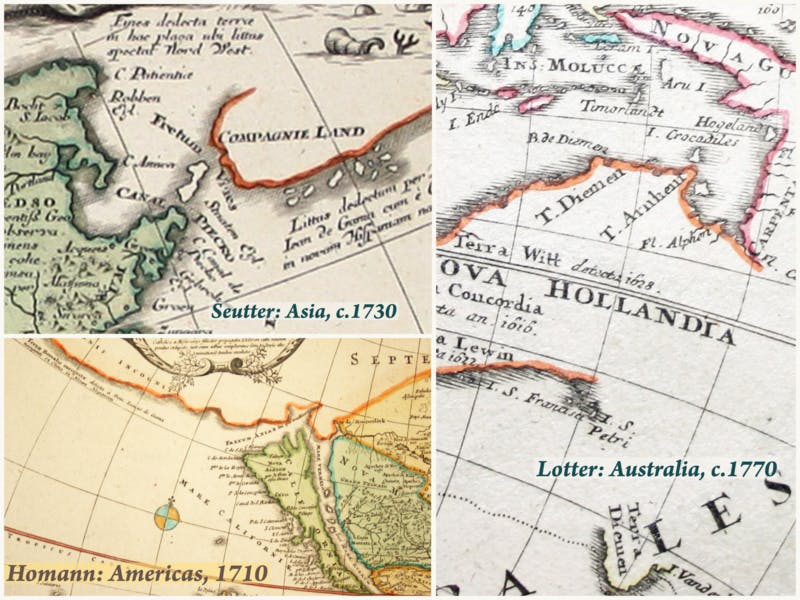
I’m going to stick with the fringes of the Pacific in the 18th century. Let’s start with a little light pre-Cook floundering around the coast of Australia, then known to Europeans as New Holland. The detail on Tobius Conrad Lotter’s world map, published in Augsburg circa 1770, is fairly typical of its day (and better than some). He has not joined all the dots by attaching Van Diemen’s Land (Tasmania) to the mainland, for example. But New Guinea is firmly tethered to Australia. When Abel Tasman visited the region in 1644, sailing eastwards along the southern coast of New Guinea before returning west along the northern coast of Australia, he missed the Torres Strait completely. It had been successfully navigated in 1606 by the Spanish, and on his early maps Hessel Gerritsz, the VOC’s first official cartographer, cites Spanish sources representing New Guinea as a separate island. However, once Tasman missed the turn off, so did almost everyone else for the next 125 years.
As it happens, on Matthäus Seutter’s map of Asia (which was also published in Augsburg, but earlier, circa 1730) the southern coast of New Guinea tails off into nothing, allowing for the possibility of a way through. But in the detail shown here, far to the north, Seutter manages to introduce an entire fictitious continent: Compagnies Landt, northeast of Japan, supposedly discovered by Jean de Gama (as a note on the map reads). There was tremendous confusion about the archipelago of islands north of Japan. Landfall was joined to landfall, and a continent emerged, which was sometimes joined to another.
Finally, let's take a look at this map of the Americas by Seutter’s former boss and business rival Johann Baptist Homann, published in Nuremberg circa 1710. Ignore the ‘island’ of California for now (we may come back to islands another time). What Homann describes as the 'unknown northern coast' has been sketched in to the northwest and identified with the conjectural Terra van Eso. Called by the Dutch ‘t Lant van Eso’, parts of the coastline can be identified with Hokkaido. So Terra van Eso, northern Japan, has been notionally joined to the western coast of North America. Even three hundred years ago the general assumption made by western cartographers, perhaps reflecting the way in which European civilisation had grown up around the Mediterranean lake, was that seas and oceans were surrounded by land rather than vice versa. Homann succumbed to temptation and joined the dots. It seemed perfectly logical that Asia and America might merge into one another, but unfortunately for Homann (or anyone using his map) they don’t.
Leave a comment